


cabredor 14octobte

clintest
User
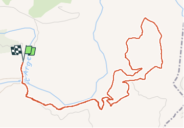

Length
8.2 km

Max alt
176 m

Uphill gradient
201 m
Km-Effort
10.8 km

Min alt
30 m

Downhill gradient
201 m
Boucle
Yes
Creation date :
2022-10-14 11:33:51.673
Updated on :
2022-10-16 18:53:22.307
2h06
Difficulty : Medium

FREE GPS app for hiking
 SityTrail
IGN / Geographical institutes
SityTrail Plus
The world is yours!
About
Trail Walking of 8.2 km to be discovered at Provence-Alpes-Côte d'Azur, Var, Les Arcs-sur-Argens. This trail is proposed by clintest.
Positioning
Country:
France
Region :
Provence-Alpes-Côte d'Azur
Department/Province :
Var
Municipality :
Les Arcs-sur-Argens
Location:
Unknown
Start:(Dec)
Start:(UTM)
298520 ; 4812058 (32T) N.
Comments